150,071 community-reported ALPR locations
Flock Camera Map: Find ALPR Cameras Near You
Use the Flock camera map to search your city, browse every U.S. state, or find documented cameras near your location. The map covers community-reported Flock Safety cameras and other automatic license plate readers across the US, Canada, UK, and Europe—no account or app required.
50
U.S. states
150,071
total cameras
Sep 21, 2026
last updated
Data: OpenStreetMap contributors. Coverage is community-reported and incomplete; the displayed date identifies the current dataset snapshot.
Open community data
Camera pins come from OpenStreetMap contributors who document ALPR equipment visible from public places. The current snapshot is free to explore with no account or paywall.
One Flock camera map
Search the national map, browse all 50 states, or jump to nearby cameras. Pins may identify Flock Safety, Motorola Solutions, Genetec, or an unknown ALPR manufacturer.
Clear source and limits
This is an independent community map, not an official Flock Safety inventory. Coverage changes as contributors add, correct, or remove locations.
Search with context
How to use the Flock camera map
Start with a place search, choose a state, or allow location access to center the map near you. Zoom in to load detailed pins, then select a camera to review its recorded manufacturer, operator, direction, and coordinates when those details are available.
01 · Find an area
Search, browse, or locate
Enter a city or address, open a state page, or use “Find cameras near me” for a local view.
02 · Inspect the pins
Review mapped details
Select a pin to see the information recorded by contributors. Missing fields remain unknown rather than being guessed.
03 · Check the limits
Treat coverage as incomplete
A missing pin does not prove an area has no ALPRs. Cameras can be new, removed, relocated, or not yet reported.
Community map—not leaked or proprietary Flock data
Recent reporting has highlighted maps built from other datasets, including a historical snapshot of Flock’s own records. This website is different: its camera locations come from community-maintained OpenStreetMap data. It does not claim to show every Flock device, planned installation, or private system record.
The basics
What is a Flock camera?
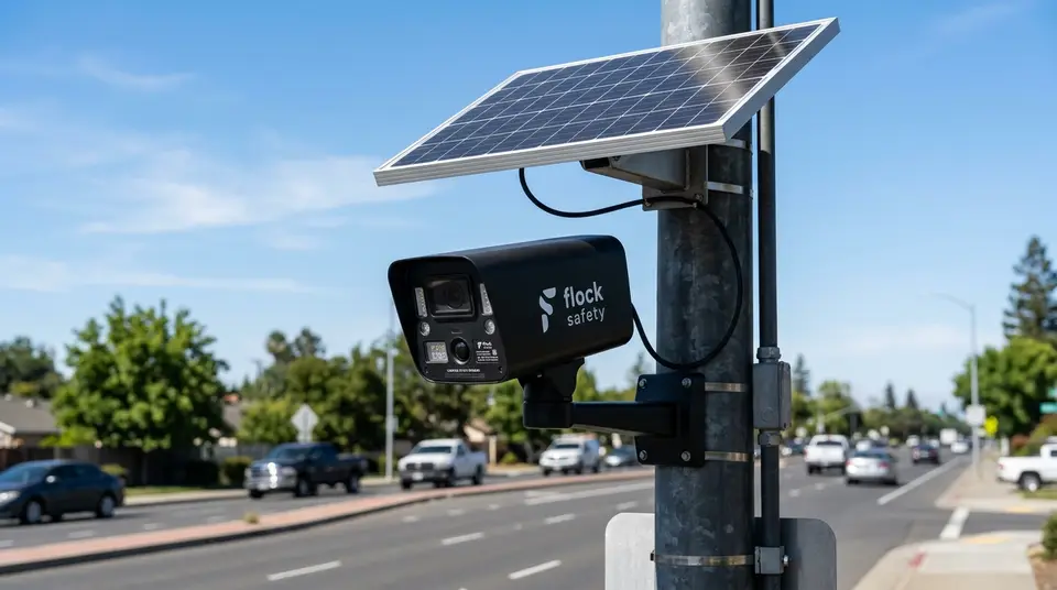
A Flock camera is a roadside automatic license plate reader made by Flock Safety. When a vehicle passes, the system creates a time-and-location record that can include the plate number, vehicle type, color, and other visible characteristics. Authorized organizations can search those observations when investigating a reported vehicle or reviewing activity in a specific area.
These devices are commonly placed near road entrances, intersections, parking areas, and neighborhood access points, often on a compact pole with a solar panel. Police agencies, municipalities, schools, homeowners associations, and private businesses may operate them. This independent Flock camera map shows locations documented by OpenStreetMap contributors, so it may include other ALPR brands and should not be treated as a complete or official inventory.
Browse
Flock camera locations by state
Pick a state to see its cameras on the map, the cities where they are most often reported, and answers to common local questions.
- United Kingdom 4,376
- Canada 27,618
- Europe 8,772
- Alabama 2,758
- Alaska 6
- Arizona 2,671
- Arkansas 1,059
- California 20,557
- Colorado 2,685
- Connecticut 995
- Delaware 442
- District of Columbia 151
- Florida 9,680
- Georgia 9,860
- Hawaii 53
- Idaho 462
- Illinois 7,375
- Indiana 3,715
- Iowa 891
- Kansas 2,100
- Kentucky 1,910
- Louisiana 2,066
- Maine 62
- Maryland 1,017
- Massachusetts 1,189
- Michigan 3,672
- Minnesota 1,486
- Mississippi 1,124
- Missouri 3,454
- Montana 69
- Nebraska 554
- Nevada 958
- New Hampshire 68
- New Jersey 2,275
- New Mexico 1,041
- New York 4,325
- North Carolina 3,691
- North Dakota 221
- Ohio 6,819
- Oklahoma 1,469
- Oregon 576
- Pennsylvania 3,634
- Rhode Island 310
- South Carolina 2,067
- South Dakota 161
- Tennessee 3,623
- Texas 16,821
- Utah 1,058
- Vermont 30
- Virginia 3,363
- Washington 2,269
- West Virginia 247
- Wisconsin 2,092
- Wyoming 72
Knowledge Base
Frequently Asked Questions
Clear answers about Flock Safety cameras, automatic license plate readers, location accuracy, privacy, and how this community map works.
What is a Flock camera and how does it work? ▼
Flock Safety cameras are Automated License Plate Readers (ALPRs) mounted on utility poles, usually powered by a small solar panel. As vehicles drive past, the camera takes high-resolution photos and automatically extracts the license plate number, state, vehicle make, model, color, and distinctive features like bumper stickers or roof racks.
Are Flock camera locations public information? ▼
Government agencies rarely publish public maps of ALPR camera locations. However, because cameras are mounted on public poles visible from public roads, community volunteers and privacy researchers document and map their coordinates on OpenStreetMap.
How long is vehicle data stored in Flock databases? ▼
By default, Flock Safety retains vehicle scan data for 30 days, after which it is automatically deleted unless flagged as evidence in an ongoing criminal investigation. However, data retention policies can vary depending on local law enforcement contracts.
How accurate is this Flock camera location map? ▼
This Flock camera map uses a published snapshot of community-reported OpenStreetMap ALPR locations across the US, Canada, UK, and Europe. It is useful for finding documented cameras, but it cannot confirm that every pin is current or that every camera in an area has been reported.
Why are Flock cameras installed in so many cities? ▼
Local police departments, municipal agencies, home owner associations (HOAs), and private businesses install Flock cameras to create a surveillance network that alerts officers in real-time when a "hotlisted" plate (such as a stolen vehicle or wanted suspect) passes by.
Do Flock cameras record video or issue speed tickets? ▼
No. Standard Flock Falcon cameras capture still photographs triggered by vehicle motion rather than continuous video streams. Additionally, Flock cameras do not issue automated speeding or red-light tickets—their primary purpose is license plate logging and crime investigation.
How can I find Flock cameras near my location? ▼
Click the "Find cameras near me" button on our live map or visit the Near Me page. Your browser will locate documented cameras within a 5-mile radius. Your location is processed entirely in your browser and is never stored or transmitted.
How do I report a new Flock camera that isn't on the map? ▼
If you spot a Flock camera or ALPR on your commute, you can report it via our "Report a Camera" guide. We provide step-by-step instructions for tagging camera locations directly on OpenStreetMap so it updates across public mapping tools.